
White Clay watershed Stream Watch program
Since 1991 the White Clay Watershed Association (WCWA), with the guidance of the Stroud Water Research Center (SWRC), has run a volunteer Stream Watch Program in the White Clay Creek (WCC). The Stream Watch program and protocols are now viewed as models throughout the region and country because of the breadth and scope of its biological survey. The Stream Watch Program is designed to use aquatic macroinvertebrates to assess water and habitat quality in the WCC. The stream is monitored at the same specific sites at the same time once a year. Samples of the aquatic macroinvertebrates, which consists mainly of insects, are collected then sorted, identified, and counted. This quantifies the biodiversity, that is, the number and variety of different families found. Some types are known to be more sensitive to environmental insult than others. It is the presence of the sensitive types, the biodiversity and total numbers of individual types that indicate the health of the stream.
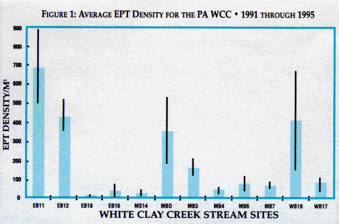
Average EPT Density is the baseline average results for the 12 PA sites of the relative numbers of the more pollution sensitive mayflies, stoneflies, and caddisflies (known collectively as EPT, i.e. ephemeroptera, plecoptera, and trichoptera). The relative numbers of these three insect orders are used as general indicators of the stream quality or health. The bars in the graph are plotted in order, starting at the headwaters of each branch of the WCC and working its~way downstream toward the DE border. The data plotted in the Figure 1 indicate that there is a decline in the water quality as one proceeds through the sites from the headwaters down into DE. The evidence is in the decline of EPT, with drastic deterioration seen at site 18 (East branch below Avondale) and the poor condition of the PA sites in the WCC Preserve, 16 (East Branch) and 14 (Main Stem), which are downstream from agricultural, commercial and residential usage. Similar but less dramatic declines are seen on the Middle and West Branches. Monitoring of three sites in Delaware (20, 21, & 22) was begun in 1995. Although we have not accumulated a 5 year baseline, the preliminary data is indicative of a similar trend of increasing deterioration as one proceeds downstream.
The condition of Site 18 is of great concern because of evidence from a 1986 PA DEP report indicating the possible contributions from point source and/or NPS pollution problems from both a tributary (Trout Run) and directly below the Avondale Sewage Treatment Plant (STP). A recent preliminary report from the PA
Department of Environmental Protection (Boyer, 1997) shows pesticides present in the water column and sediments of the East Branch above and below Avondale. Pesticides were also present in two tributaries that empty into the East Branch near Avondale. The pesticide levels are a reflection of both current and past uses.
WCWA's Stream Watch data in combination with the Geographical Information Systems (GIS) land use maps indicate that point source and/or nonpoint source (NPS) pollution may be contributing factors to the decline in water quality. The landcover (i.e. land use) well as other land features (slope, stream side forests) are components of the landscape which determine the extent of erosion and run off for that geographical area. The GIS information, along with the WCWA Stream Watch data, provide the prudent landowner and municipality with information for changing land practices in order to improve the quality of the surrounding area.
The WCWA is currently in the final stages of preparation of a River Management Plan for the Pennsylvania portion of the watershed. Designed as a complement to this plan, the PA plan focuses on water quality and is based on the results of the Stream Watch Program in conjunction with a GIS study of land use in the watershed.